
पटिमा:Playfair piecharts.jpg

Size of this preview: ८०० × ४३८ pixels. Other resolutions: ३२० × १७५ pixels | ६४० × ३५१ pixels | १,०२४ × ५६१ pixels | १,२८० × ७०२ pixels | २,५६० × १,४०३ pixels | ६,३०६ × ३,४५६ pixels.
Original file (६,३०६ × ३,४५६ pixels, file size: ५.३६ MB, MIME type: image/jpeg)
| This is a file from the Wikimedia Commons. Information from its description page there is shown below. Commons is a freely licensed media file repository. You can help. |
Summary
| Description |
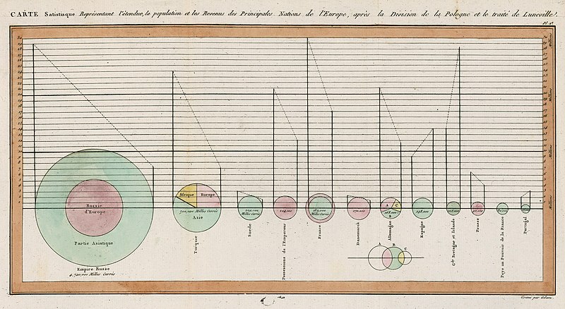
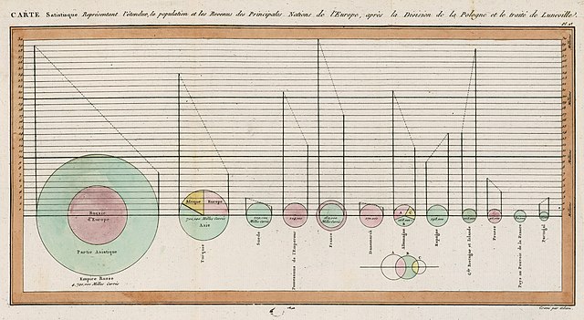
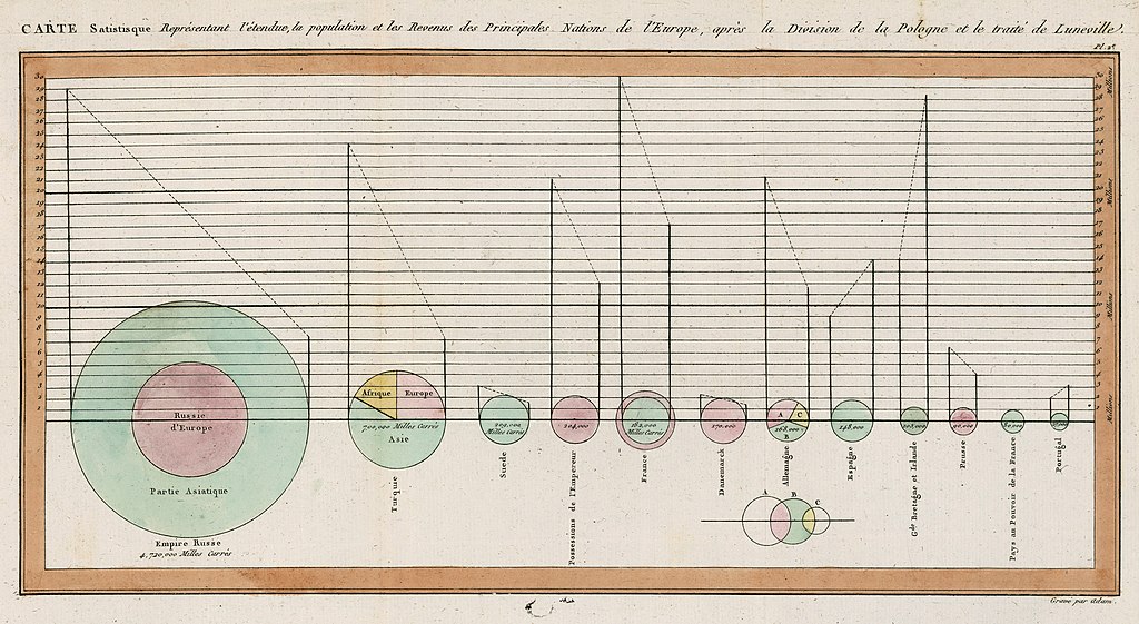
English: Statistical map showing the extent, population and income of the principal nations of Europe, after the division of Poland and the treaty of Luneville. |
||||||||||||||||
| Date | |||||||||||||||||
| Source | Statistical Breviary. David Rumsey Map Collection, courtesy Stanford University Libraries | ||||||||||||||||
| Author |
|
||||||||||||||||
| Other versions | Image:Playfair-piechart.jpg (a selection from this chart) | ||||||||||||||||
Licensing
|
This is a faithful photographic reproduction of a two-dimensional, public domain work of art. The work of art itself is in the public domain for the following reason:
The official position taken by the Wikimedia Foundation is that "faithful reproductions of two-dimensional public domain works of art are public domain".
This photographic reproduction is therefore also considered to be in the public domain in the United States. In other jurisdictions, re-use of this content may be restricted; see Reuse of PD-Art photographs for details. | ||||
File history
Click on a date/time to view the file as it appeared at that time.
| Date/Time | Thumbnail | Dimensions | User | Comment | |
|---|---|---|---|---|---|
| current | ०८:५५, ५ मार्च २०२३ | | ६,३०६ × ३,४५६ (५.३६ MB) | Sette-quattro | higher quality scan from same source |
| १९:००, ७ जुलाई २००८ |  | १,०५० × ५८७ (१६१ KB) | Mdd | {{Information |Description={{en|1=Pie charts from Playfair's "Statistical Breviary" }} |Source=Scanned from the book "The Commercial and Political Atlas and Statistical Breviary", Cambridge University Press 2005. |Author=William Playfair (1759–1823) |Da |
File usage
There are no pages that use this file.
Global file usage
The following other wikis use this file:
- Usage on cs.wikipedia.org
- Usage on en.wikipedia.org
- Usage on eu.wikipedia.org
- Usage on fr.wikipedia.org
- Usage on he.wikipedia.org
- Usage on id.wikipedia.org
- Usage on ms.wikipedia.org
- Usage on oc.wikipedia.org
- Usage on ta.wikipedia.org
- Usage on uk.wikipedia.org
- Usage on uz.wikipedia.org